Coronavirus updates and guidance

COVID-19


  • Contact Us
  • Privacy Policy
  • EN
  • |
  • AL
Menu
Bashkia e Tiranës logo
15 ℃

21 May 2025

0800 0888 Free Number
Administrative
Areas
Tirana map
  • Administration and Citizens
  • Culture & Events
  • Tourism
  • Economy and Business
  • City Map Get Involved
Administrative
Areas
Tirana map
Menu Close
  • Administration and Citizens
  • Culture & Events
  • Tourism
  • Economy and Business
  • City Map
  • Your Voice
  • Applications and Information
    • Dependency Institutions and Agencies
    • Applications for the citizens
  • Legislation and Administration
    • Mayor of Municipality
    • Deputy Mayors
    • Municipal Council
  • Activities and Publications
    • Latest News & Events
  • Education
    • Pre-kindergartens
    • Kindergartens
    • Schools
  • Cultural Projects
    • Cultural Priorities
    • Calendar of activities
    • Cultural Activities
    • Calls for applications
  • Culture Heritage
    • On Culture Heritage
    • Tangible Culture Heritage
    • Intangible Culture Heritage
    • Priorities
    • Cultural Heritage Activities
    • Proposals for naming parts of public territory
    • Contact
  • Events
    • Photos & Videos from activities
  • Tirana History
    • Tirana - Short Story
    • Heritage and Architecture Evolution
  • Plan Your Trip
    • Arriving in Tirana
    • 1,2,3 days in Tirana
    • A Journey through TIRANA
    • City Map
    • Strolling Tirana
  • Discover Tirana
    • Tirana City Map
    • Theatres and Cinemas
    • Attractions and Sights
    • Museums
    • Galleries and Art Spaces
    • Religious Objects (Religious Harmony)
    • Tirana Surroundings
  • Agribusiness
    • Agritourism
    • Traditional restaurants
    • Handicraft workshops
  • Eat, Drink, Shop
    • Accommodation
    • Restaurants
    • Bars
    • Nightlife
    • Shopping areas
  • Airports and Transport
    • Airports
    • Bicycle Rental
    • Rent a car
    • Bus Lines
    • Terminals
  • Contact and Utilities
    • Emergencies and Hospitals
    • Info Points
    • ATM
    • Post Offices
    • Guides and tour operators
    • Libraries
    • Contact Us
  • Business & Financial Opportunities
    • Invest in Tirana
    • Business Angels
  • Diaspora and Migration
  • Projects
    • Lana River
    • Swedfund project
    • Vocational School
  • City Map
    • Bars
    • Restaurants
    • Tourism
    • Culture
    • Transportation
    • Administration Offices
    • Tirana Bus Map
  • Transparency
    • Forum
    • Territorial Planning and Development
    • Open Data
    • Project Financing
    • Walkability App

Emergency Numbers

Fire - 128

Ambulance - 127

Police - 129

  • Administration and Citizens
    • Applications and Information
      • Dependency Institutions and Agencies
      • Applications for the citizens
    • Legislation and Administration
      • Mayor of Municipality
      • Deputy Mayors
      • Municipal Council
    • Activities and Publications
      • Latest News & Events
    • Education
      • Pre-kindergartens
      • Kindergartens
      • Schools
  • Culture & Events
    • Cultural Projects
      • Cultural Priorities
      • Calendar of activities
      • Cultural Activities
      • Calls for applications
    • Culture Heritage
      • On Culture Heritage
      • Tangible Culture Heritage
      • Intangible Culture Heritage
      • Priorities
      • Cultural Heritage Activities
      • Proposals for naming parts of public territory
      • Contact
    • Events
      • Photos & Videos from activities
  • Tourism
    • Tirana History
      • Tirana - Short Story
      • Heritage and Architecture Evolution
    • Plan Your Trip
      • Arriving in Tirana
      • 1,2,3 days in Tirana
      • A Journey through TIRANA
      • City Map
      • Strolling Tirana
    • Discover Tirana
      • Tirana City Map
      • Theatres and Cinemas
      • Attractions and Sights
      • Museums
      • Galleries and Art Spaces
      • Religious Objects (Religious Harmony)
      • Tirana Surroundings
    • Agribusiness
      • Agritourism
      • Traditional restaurants
      • Handicraft workshops
    • Eat, Drink, Shop
      • Accommodation
      • Restaurants
      • Bars
      • Nightlife
      • Shopping areas
    • Airports and Transport
      • Airports
      • Bicycle Rental
      • Rent a car
      • Bus Lines
      • Terminals
    • Contact and Utilities
      • Emergencies and Hospitals
      • Info Points
      • ATM
      • Post Offices
      • Guides and tour operators
      • Libraries
      • Contact Us
  • Economy and Business
    • Business & Financial Opportunities
      • Invest in Tirana
      • Business Angels
    • Diaspora and Migration
    • Projects
      • Lana River
      • Swedfund project
      • Vocational School
  • City Map
    • City Map
      • Bars
      • Restaurants
      • Tourism
      • Culture
      • Transportation
      • Administration Offices
      • Tirana Bus Map
  • Your Voice
    • Transparency
      • Forum
      • Territorial Planning and Development
      • Open Data
      • Project Financing
      • Walkability App

Emergency Numbers

Fire - 128
Ambulance - 127
Police - 129

Tirana Surroundings

  • Home
  • Tourism
  • Tirana Surroundings
  • Bovilla Lake

    Erion Veliaj - Youtube

    Twitter

    Tweets by City Of Tirana

    Bovilla Lake

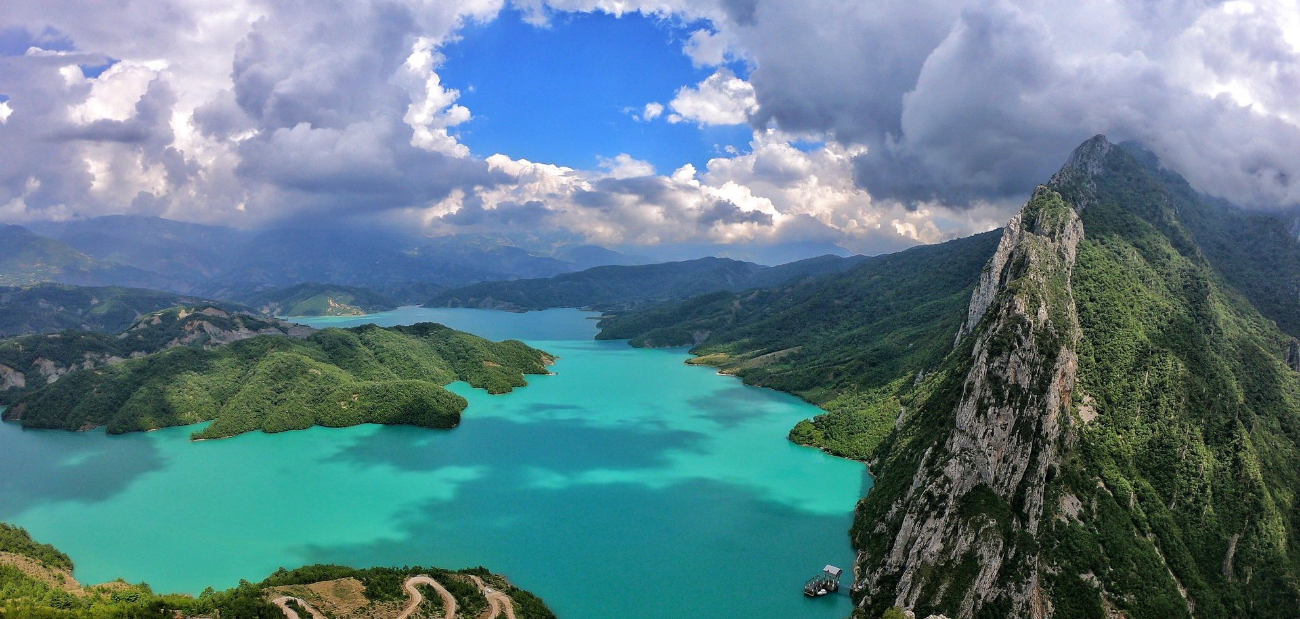
    Bovilla Lake is located 15 km in the northeast of Tirana. It was formed 15 years earlier on the upper part of Terkuza River, positioned between the two ranges of mountains Kruja-Dajt and Skënderbe-Mali me Gropa, a space in the regions of Kruja and Tirana. The lake is limited in the west with the Gami Mountain (1.267 m) and Brari Mountain (1.214 m) and from Dajt Mountain (1.613) in the southeast. In the east, it is limited with the Xibri Mountains (1.531m) and Koti Mountains (1.391m) positioned in the northwest between Scanderbeg Mountain and Mountain with Pits  in the south east. 
    The watershed is formed by the interruption of Tërkuza River with a dam which is 81-metre-high in Zall Herr Ravine. From 1998, Bovilla watershed is the main supplier with about 50% of the entire consumption of the drinkable water for Tirana and the entire inhabited region. 
    The relief is hilly-mountainous, where the erosion and the soil slides are very active. The surface of the lake is 4.6 km and it is 18-53 m deep. The vegetation in Bovilla region includes four phyto climatic zones: Region of the Mediterranean forests and shrubs (300 – 600m), Oaks Region (600 – 1000m), Beech Zone (1.000 – 1.600m) and the Mountainous Pasture Zone (over 1.500m).


    The region around Bovilla has a stunning beauty with Bovilla waterfall, Bovilla ravine and the surrounding rocks. Several tourist agencies and operators use this relief for mountaineering and climbing up the rocks. Apart from the youngsters, lots of tourists passionate of nature and adventure take part in the relevant itineraries. The itineraries vary in the level of difficulty, from the simplest ones to the most difficult ones, in order for everybody to have an opportunity in climbing and mountaineering. 
     

    Virtual Tour

    Need Help?

    • Contact us through E-mail or Telephone
    • 0800 0888
    • [email protected]
    • Skanderbeg Square, Postal code 1001, Tirana, Albania

    Tirana

    • Privacy Policy
    • Contact Us